Lake Michigan’s run of record-breaking water levels is washing away parts of Wisconsin’s eastern shores.
 Lucas Zoet
To quantify that erosion, Lucas Zoet, an assistant professor of geoscience at UW-Madison, is using drones and working with high school students to study the shifting shores from above, thanks to a $4,000 Baldwin Wisconsin Idea Seed Project Grant.
The project builds on ongoing research in collaboration with the National Oceanic and Atmospheric Administration and Wisconsin Sea Grant to study the coastline and model how changes in lake levels shape its evolution. Much of that research as focused on the shoreline around Milwaukee and extending about 50 miles north and south of the city.
Zoet, who is a faculty member in the Geological Engineering Program, says he will leverage the methods employed in that research to now study the coast around Door County, Wisconsin’s “thumb,” in northeast Wisconsin—and that will give area high school students a chance to get involved in the process.
To study the shoreline, Zoet will use drones to take thousands of pictures from different points in the air. A photogrammetry method called structure from motion allows those flat, 2D images to be constructed into 3D models, in a way that’s similar to how the slight offset in what human eyes see allows us to perceive depth.
“The drone does the same thing,” Zoet says. “It’s only got one camera, but it can take a picture in one spot, then fly to the next spot and take another picture, and from those two pictures figure out the range to different points. You do that with thousands of pictures and you can basically reconstruct a whole bluff.”
The data Zoet’s team collects about how far and how quickly the shore is retreating can be fed into sophisticated models that can help the researchers understand the processes that drive erosion. Understanding those processes and changes in the shoreline is particularly important now, as Lake Michigan continues to swell after recovering from record-low levels in 2013. The lake’s levels have broken records every month so far in 2020, and it currently sits at just over 582 feet. That’s just below the highest level ever recorded in 1986.
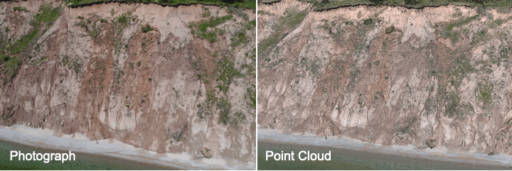 This image shows a point cloud. Each point in the image has an x, y and z coordinate as well as a color. When many of points are collected and grouped tightly together, they can be used to recreate terrain.
The U.S. Army Corps of Engineers forecasts that lake levels will continue to rise through summer 2020, which will expose new areas to erosion and compound ongoing issues such as coastal landslides. In fact, water levels across the Great Lakes are high, driven in part by heavy rains, and are causing hundreds of millions of dollars in damage across the region.
“Right now, Lake Michigan is one inch away from the highest level that’s ever been recorded,” Zoet says. “If you went out to the beaches along Lake Michigan in 2013, you might have had 100 feet of beach. But the slope on a beach is really shallow, so if you raise the water level by about three feet—as the lakes have—that means all of the beach is now under water and the waves are free to erode the bluffs or whatever land might be behind the beach.”
As part of the project, Zoet is partnering with the Global Learning and Observation to Benefit the Environment (GLOBE) program, a worldwide science and education initiative, to put drones in the hands of high school teachers. Teachers and their students will first learn to work with drones using 10 small, inexpensive models, then they’ll move to a research-grade DJI Phantom drone will be made available to rotate through classes. Zoet’s team plans to begin working with teachers to initiate them on drone usage in fall 2021.
His work will not only provide hands-on scientific experience for students (and their teachers), but in the process, it will help him and other researchers monitor how the shoreline changes over time—even when they can’t be there to study it in person.
“If we can’t collect data, we can’t even say anything about how things have changed over time,” Zoet says. “One of the big limitations is being able to get to these places. If we can have a group of people—like these high school students and teachers—who are interested in it, that increases our ability to keep our eye on a lot of different locations we’d otherwise never be able to get to.”